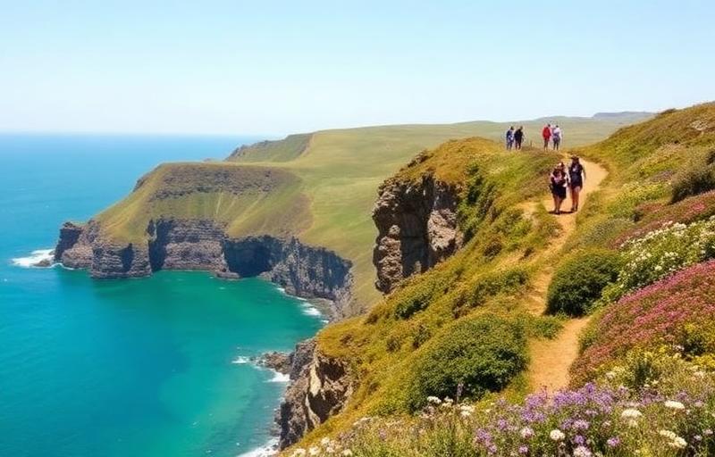
Section 1: Amroth to Pembroke
The Pembrokeshire Coast Path is one of Britain's most celebrated long-distance walking routes, and this opening section sets the tone perfectly, delivering a remarkable mix of industrial heritage, Norman history, dramatic clifftops, and some of the finest beaches in Wales. Beginning at a stone marker opposite the New Inn pub in the village of Amroth, walkers step onto an expansive pebble beach before the path climbs steeply to reward them with their first sweeping coastal views.
The early miles carry a surprising layer of history. The beach at Wiseman's Bridge served as a rehearsal site for the D-Day landings during World War II, while the old tramway route that carries the path onward to Saundersfoot was built in 1835 to haul coal and iron ore to the harbour. The path passes through tunnels cut directly into the cliffs, emerging between them onto an elevated walkway above the sea. Saundersfoot itself is a bustling former coal port, its harbour completed in 1834, and a good place to rest before the route climbs again through woodland where red squirrels still live.
The approach to Tenby is one of the section's highlights. The path winds through bluebell-filled woodland, crosses streams on wooden bridges, and climbs beside 300-foot cliffs with views stretching as far as Caldey and Lundy Islands before descending into this picture-postcard medieval walled town with its golden beaches and castle ruins. From Tenby, the route heads south along two kilometres of Blue Flag sand before rounding Giltar Point and continuing above rugged limestone cliffs to the sheltered bay at Lydstep Haven.
The geology becomes increasingly dramatic further along. At Skrinkle Haven, the Church Doors, a pair of massive natural limestone arches framing knife-edge ridges and tiny coves below, are genuinely unforgettable. A steep descent of 140 steps brings walkers down to the golden sands if they choose to explore. Shortly after, Manorbier Bay appears almost without warning, a wide sandy beach presided over by a fairy-tale Norman castle, with King's Quoit, a 3,000-year-old Neolithic burial chamber, standing at the bay's eastern edge.
The route continues through quieter country past the smugglers' haunt of Swanlake Bay, the sweeping dunes of Freshwater East, and the National Trust's celebrated Stackpole Estate, where the Bosherston Lily Ponds support otters, kingfishers, and over 20 species of dragonfly. World-renowned Barafundle Bay, often compared to a Caribbean beach, sits just a short walk from Stackpole Quay and has been voted one of the best beaches in Britain.
After crossing the perimeter of the Castlemartin military range, where the occasional rumble of artillery serves as an unusual companion, the path arrives at the vast surf beach of Freshwater West before tackling one of the route's most demanding stretches to West Angle Bay. From here, the final miles pass a Tudor blockhouse built by Henry VIII and follow the shores of the Milford Haven estuary, delivering walkers into the historic town of Pembroke beneath the towering walls of the castle where Henry VII was born in 1457. It is a fitting end to an exceptionally varied and rewarding walk.
Section 2: Pembroke to St David's
Leaving the medieval walls of Pembroke Castle behind, the trail follows riverside paths through woodland around millponds before crossing into Pembroke Dock, Wales' only Royal Dockyard. Established in 1814, this historic installation launched over 260 Royal Navy vessels during its operational years, and its defensive walls and Martello Tower still stand as reminders of its strategic importance. The path then climbs to the Cleddau Bridge, one of Europe's longest unsupported spans, where views stretch across the estuary in both directions before the descent into Neyland, where a statue of Isambard Kingdom Brunel marks the spot where he brought the Great Western Railway to Pembrokeshire in the 1850s.
The route continues through quiet villages and waterside woodland along the Milford Haven Waterway, a working estuary on a grand scale. This is one of the world's great natural harbours, handling a quarter of Britain's gas requirements, and the path threads between industrial installations and wooded stretches with a fascinating contrast between the working port and its natural surroundings. Milford Haven's marina provides a welcome break with restaurants and cafes before the trail winds west past the vast South Hook LNG terminal, Europe's largest regasification facility, toward the quieter waters of Sandy Haven Estuary.
Beyond Sandy Haven, the landscape begins to open up into something wilder and more remote. The path rounds headlands bearing the earthwork remains of Iron Age forts at Little Castle Head and Great Castle Head, passes the sheltered stone beach at Monk Haven with its ruined Victorian folly tower, and eventually reaches Dale village on the peninsula's shore. From Dale, the walking becomes genuinely spectacular as the trail follows the western coastline past Victorian coastal defences and down to Mill Bay, where a plaque marks the precise spot where Henry Tudor landed on August 7th, 1485 with 2,000 French mercenaries before marching to defeat Richard III at Bosworth Field. From here the path climbs past St Ann's Head lighthouse before swinging north to reveal Marloes Sands below, a mile-long golden beach between towering red sandstone cliffs that is among the finest in Wales.
The route continues to Martin's Haven, departure point for boat trips to Skomer Island and its famous puffin colonies, before heading north along clifftops above St Brides Bay. The walking through this stretch combines dramatic coastal scenery with unexpected details, a natural arch at Den's Door, the eccentric grass-roofed Malator house built into the hillside above Druidston Haven, and a solitary colliery chimney at Trefayne. The sweeping two-mile surf beach at Newgale marks a transition to the most dramatic walking of the entire section.
From Newgale, the path becomes increasingly demanding, rolling over headlands and plunging into hidden coves as it pushes west. The secluded beach at Porthmynawyd is considered by many the finest along the entire route. After the picturesque harbour village of Solva, the trail passes cliffs of distinctive purple sandstone, quarried for centuries to build St David's Cathedral, before turning inland to reach Britain's smallest city. Standing in the shadow of that magnificent cathedral, walkers arrive at a genuinely historic destination and a fitting landmark on one of Wales' great coastal walks.
Section 3: St Davids to St Dogmaels
Leaving Britain's smallest city, the trail heads south to the coast and the evocative ruins of St Non's Chapel, birthplace of Wales' patron saint, where a holy well beside the medieval remains has drawn pilgrims for centuries. From here the path traces spectacular rocky cliffs westward with Ramsey Island visible across the water and grey seals frequent in the coves below. After passing the sheltered harbour at Porth Clais and the dramatic lifeboat station at St Justinian, where tidal currents through Ramsey Sound can reach seven knots, the route arrives at Whitesands Bay, one of Pembrokeshire's finest beaches, dominated by the volcanic peak of Carn Llidi rising behind.
The path then rounds St David's Head, one of the wildest and most atmospheric stretches of the entire route. This windswept headland, formed from rock dating back 500 million years and described by the Romans as the Promontory of the Eight Perils, is scattered with ancient field patterns, Iron Age remains, and Coetan Arthur, a Neolithic burial chamber with a capstone nearly six metres wide. Gannets dive offshore and grey seals haul out in the rocky coves below as the path rounds a succession of deep inlets northward toward Abereiddy, where the famous Blue Lagoon, a flooded former slate quarry with striking blue-green water, makes for an extraordinary industrial relic on an otherwise wild coastline.
The walking continues through Porthgain, a harbour village whose massive brick crushing hoppers from the old granite export trade give it a character unlike anywhere else on the path. The Sloop Inn and the Shed restaurant make this an excellent stop. Beyond Porthgain the route becomes increasingly remote, threading above sheer clifftops past sheltered beaches and lonely coves before reaching Aber Mawr, a peaceful pebble bay ideal for seal watching in autumn. The stretch approaching Pwll Deri is among the most spectacular in Pembrokeshire, with the path high above crashing waves on one side and open moorland sweeping inland on the other.
Strumble Head brings the section's most dramatic viewpoint, where the 1908 lighthouse sits on its own small island and the headland offers a prime position for watching porpoises, dolphins, and migrating seabirds. From here the path heads east to Carregwastad Point, where a monument marks the site of Britain's last invasion in February 1797, when 1,400 French troops landed and surrendered just three days later. After Fishguard, the route passes through some genuinely wild terrain, climbing to the summit of Dinas Head at 142 metres with views reaching the Llŷn Peninsula on a clear day and down to the dramatic sea stack of Needle Rock below.
The final miles are the most demanding of the entire Pembrokeshire Coast Path, tackling some of the highest cliffs in Wales and climbing over 900 metres in total before Cemaes Head. The geological drama is extraordinary throughout, from the collapsed sea cave of Pwll y Wrach to the ancient folded rock formations at Pen yr Afr. The trail descends finally to Poppit Sands and follows a quiet road into St Dogmaels, where a commemorative marker beside the Ferry Inn marks the end of one of Britain's truly great coastal walks.